Hurricane Sandy Bears Down: What to Expect
Hurricane Sandy, the potentially "life-threatening" superstorm, is bearing down on the Eastern Seaboard. And while the eye of the storm is not expected to hit the mid-Atlantic coast until late Monday afternoon, many residents are already feeling the Category 1 storm's impact.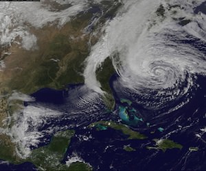
Hurricane Sandy, the potentially “life-threatening” superstorm, is bearing down on the Eastern Seaboard. And while the eye of the storm is not expected to hit the mid-Atlantic coast until late Monday afternoon, many residents are already feeling the Category 1 storm’s impact.
The storm has begun to push ashore with wind speeds of up to 85 miles per hour, affecting residents from Virginia to Massachusetts. In preparation, mass transit has ground to a halt on the Eastern Seaboard, while many schools and businesses have been shut down because of the impending storm. The New York Stock Exchange is also planning a rare weather-related shutdown, something it has not done since 1985.
Thousands of flights have also been canceled ahead of the storm in the Northeast and across the country.
According to CNN, over the next 24 to 48 hours those within the storm’s range can expect the following: hurricane-force winds, a massive storm surge, heavy rains, flooding and snow. Power outages affecting tens of millions are expected as well.
CNN:
Landfall will occur Monday evening into overnight, and storm surge likely will peak around the evening high tide. (Remember Monday’s tides are already the largest of the month due to the full moon.) On Tuesday, rain and snow will continue for much of the area, and surf will remain rough as the center of the system slowly drifts northward into Pennsylvania and New York.
… Because of the size of this system, the effects will be felt far from the center. For example, large waves and surge will be felt in eastern Canada and along the shores of the eastern Great Lakes. Also, when Sandy transitions from hurricane or tropical storm to “post-tropical storm,” it does not mean it has weakened or the threat is any less.
Forecasters are warning that the superstorm spawned by the hurricane’s collision with a cold front represents a “worst-case scenario.” It has even been compared to the deadly and destructive Hurricane Katrina, which hit the Gulf Coast in 2005.
The Huffington Post:
In a measurement of pure kinetic energy, NOAA’s hurricane research division on Sunday ranked the surge and wave “destruction potential” for Sandy – just the hurricane, not the hybrid storm it will eventually become – at 5.8 on a 0 to 6 scale. The damage expected from winds will be far less, experts said. Weather Underground meteorologist Jeff Masters says that surge destruction potential number is a record and it’s due to the storm’s massive size.
… The storm surge energy numbers are bigger than the deadly 2005 Hurricane Katrina, but that can be misleading. Katrina’s destruction was concentrated in a small area, making it much worse, Masters said. Sandy’s storm surge energy is spread over a wider area. Also, Katrina hit a city that is below sea level and had problems with levees.
The hurricane has already claimed 65 lives in the Caribbean.
— Posted by Tracy Bloom.
Your support matters…Independent journalism is under threat and overshadowed by heavily funded mainstream media.
You can help level the playing field. Become a member.
Your tax-deductible contribution keeps us digging beneath the headlines to give you thought-provoking, investigative reporting and analysis that unearths what's really happening- without compromise.
Give today to support our courageous, independent journalists.
 The dry zone of the United States is spreading eastward because of climate change.
You need to be a supporter to comment.
There are currently no responses to this article.
Be the first to respond.