America’s Arid West Is Invading the Fertile East
The dry zone of the United States is spreading eastward because of climate change.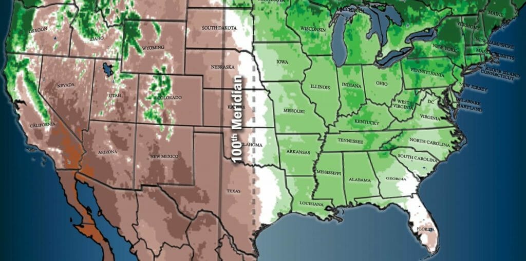 The 100th meridian (solid line) is seen as dividing the moister eastern U.S. from the dryer west. Climate change may already be moving the divide eastward (dotted line). (Image modified by the Climate News Network from Seager et al, Earth Interactions 2018)
Theres an invasion going on down the middle of the US, as America’s arid West advances eastwards. Imperceptibly, decades of climate change have shifted the natural boundary between the dry west and the fertile farmlands of the eastern states by more than 225 kilometres, according to a new study by US scientists.
In effect, what was once marked by the 100th meridian is now at 98 degrees of longitude.
The 100th meridian is one of those astronomically-determined lines that emerge from what the researchers call “psychogeography.” Just as the historic 38th parallel separates the hostile states of North and South Korea, the Mason-Dixon line marks a notional but blood-stained boundary between the northern states and the American South, and the Greenwich meridian formally replaced the Paris meridian as the notional ground zero for the measure of universal time, so the 100th meridian has entered US consciousness.
It was first cited 140 years ago when a pioneer geologist and surveyor identified a divide running from north to south between land that received ample rainfall, and soils in the so-called rain-shadow of the Rockies that could be classed as arid.
And, conveniently, it could be measured as 100 degrees west of Greenwich in the UK, the starting point for lines of longitude. In two papers in the journal Earth Interactions, researchers have taken a closer look at the reality of this historic divide and the changing nature of the US landscape as a consequence of climate change driven by ever-greater ratios of greenhouse gases in the atmosphere, in response to ever-more profligate human use of fossil fuels.
They confirm that in the 140 years since the first observation of that divide, the line through North and South Dakota, Nebraska, Kansas, Oklahoma and Texas has shifted eastwards by 140 miles, or 225 km: in the state of Texas, this is a shift from Abilene to Fort Worth.
In 1878, the geologist John Wesley Powell noted the transformation observed as he crossed a north-south band of terrain in the US. “On the east, luxuriant growth of grass is seen, and the gaudy flowers of the order Compositae make the prairie landscape beautiful.
“Passing westward, species after species of luxuriant grass and brilliant flowering plants disappear; the ground gradually becomes naked, with ‘bunch’ grasses here and there; now and then a thorny cactus is seen, and the yucca plant thrusts out its sharp bayonets,” he later wrote.
Big change ahead
Today, west of the line, population drops away sharply and farms are fewer but bigger. To the east, most of the crop is maize, a plant greedy for water. To the west, the dominant harvest is wheat, which is more resistant to aridity.
The researchers predict that drylands will continue to move eastward with the century, as global temperatures continue to rise, and eventually trigger large-scale changes.
Such research is simply another way of identifying the impacts of climate change. None of it should be a surprise. Researchers have repeatedly warned that the US climate is changing with ever-greater risks of climate extremes, including ever-more devastating droughts, and with increasing risks of forest fire.
So the 100th meridian study is another way of telling the story again. “Powell talked eloquently about the 100th meridian, and this concept of a boundary line has stayed with us down to the current day,” said Richard Seager of Columbia University’s Lamont-Doherty Earth Observatory, who led the study. “We wanted to ask whether there really is such a divide, and whether it’s influenced human settlement.”
Your support matters…Independent journalism is under threat and overshadowed by heavily funded mainstream media.
You can help level the playing field. Become a member.
Your tax-deductible contribution keeps us digging beneath the headlines to give you thought-provoking, investigative reporting and analysis that unearths what's really happening- without compromise.
Give today to support our courageous, independent journalists.
 Economic Justice
The White House's 'Solar for All' program is designed to reduce greenhouse emissions and energy inequity.
Economic Justice
The White House's 'Solar for All' program is designed to reduce greenhouse emissions and energy inequity.
 Editorial Cartoons
 Activism
Indigenous peoples around the world are harassed and killed at alarming rates. Will the world act?
Activism
Indigenous peoples around the world are harassed and killed at alarming rates. Will the world act?
 Editorial Cartoons
 Environment
Regulators just imposed unprecedented fees on water usage in the state’s agricultural heartland.
Environment
Regulators just imposed unprecedented fees on water usage in the state’s agricultural heartland.
 Environment
Despite record heat waves and biblical floods, Middle Eastern leaders continue to do as little as possible to combat the reality of climate change.
Environment
Despite record heat waves and biblical floods, Middle Eastern leaders continue to do as little as possible to combat the reality of climate change.
You need to be a supporter to comment.
There are currently no responses to this article.
Be the first to respond.