Hundreds of Millions of Us Now Live in Danger of Flooding
A new approach to measuring land height finds that the numbers of people already at risk from sea level rise have multiplied threefold.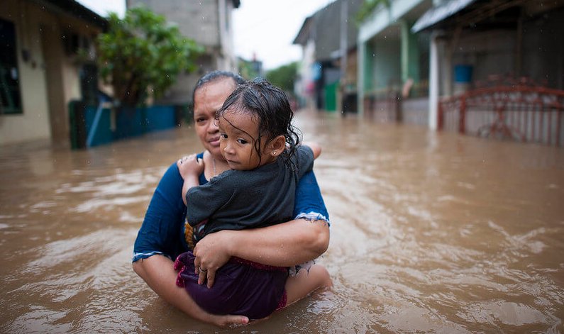 The reality of coastal flooding in Jakarta, Indonesia. (Kompas/Hendra A Setyawan / Climate Visuals)
Researchers have taken a closer look at estimates of coastal land height – and found that the numbers of people already at risk from sea level rise driven by global heating have multiplied threefold.
More than 100 million people already live below the high tide line, and 250 million live on plains that are lower than the current annual flood heights. Previous estimates have put these numbers at 28 million, and 65 million.
And even if the world takes immediate drastic action and reduces greenhouse gas emissions by the end of the century, at least 190 million people will find themselves below sea level.
If the world’s nations continue on the notorious business-as-usual track and go on burning ever greater volumes of fossil fuels, then around 630 million will, by the year 2100, find themselves on land that will be below the expected annual flood levels.
Protection in question
“These assessments show the potential of climate change to reshape cities, economies, coastlines and entire global regions within our lifetime,” said Scott Kulp of Climate Central, who led a study published in the journal Nature Communications.
“As the tideline rises higher than the ground people call home, nations will increasingly confront questions about whether, how much, and how long coastal defences can protect them.”
At the heart of the new research is a revised estimate of what constitutes sea level, and how it should be measured. Individuals and communities find out the hard way how the highest tides can rise to poison their farmlands with salt and wash away the foundations of their homes.
But the big picture – across nations and regions worldwide – is harder to estimate: for decades researchers have relied on satellite readings, confirmed by flights over limited spaces with radar equipment.
“There is still a great need for . . . more accurate elevation data. Lives and livelihoods depend on it”
But space-based readings by Nasa’s radar topography programme tend to be over-estimates, the researchers argue. That is because the technology measures the height of the first reflecting surface the radar signal touches. In open country, this may not matter. But forests and high buildings in densely-peopled cities distort the picture.
In parts of coastal Australia, and using a new approach, the researchers found that satellite readings delivered over-estimates of 2.5 metres. So global averages in the past have over-estimated, by around 2 metres, the elevation of lands that are home to billions.
Research of this kind helps clarify the challenge that faces governments, civic authorities and private citizens: communities grow up along low-lying coasts and estuaries because these provide good land, reliable water supplies and easy transport. But the catch with flood plains is that, sooner or later, they flood.
The repeated evidence of a decade of climate science is that floods will become more devastating, more frequent and more prolonged for a mix of reasons.
Multiple risks
Soils will subside because of the growing demand for groundwater and for clays and stone for bricks and mortar; because global average temperatures will rise and oceans expand as they warm; glaciers will melt and tip more water into the sea to raise ocean levels; and tropical cyclones will become more intense to drive more destructive storm surges.
Researchers have already warned that sea level rise could be accelerating, to bring more flooding to, for instance, the great cities of the US coasts, while some cities can expect ever more battering from Atlantic storms.
Coastal flooding is likely to create millions of climate refugees even within the US, and the worldwide costs of coastal flooding could reach $1 trillion a year by the end of the century.
The latest study confirms that the hazards are real, and may have so far been under-estimated. The researchers calculated that, in parts of China, Bangladesh, India, Vietnam and Thailand, places now home to 237 million people could face coastal flooding every year by 2050 – a figure 183 million higher than previous estimates.
U.S. coasts threatened
The same study highlights faulty estimates of ground elevation even in the richest and most advanced nations. In some parts of the crowded coastal cities of New York, Boston and Miami, for instance, the researchers believe satellite readings have over-estimated ground height by almost five meters. They say their new approach reduces the margin of error to 2.5 cms.
Right now, around a billion people live on lands less than 10 meters above high tide levels. Around 250 million live within one meter above high tide.
“For all of the critical research that’s been done on climate change and sea level projections, it turns out that for most of the global coast we didn’t know the height of the ground beneath our feet,” said Benjamin Strauss, president and chief scientist of Climate Central, and co-author.
“Our data improves the picture, but there is still a great need for governments and insurance companies to produce and release more accurate elevation data. Lives and livelihoods depend on it.”
Your support matters…Independent journalism is under threat and overshadowed by heavily funded mainstream media.
You can help level the playing field. Become a member.
Your tax-deductible contribution keeps us digging beneath the headlines to give you thought-provoking, investigative reporting and analysis that unearths what's really happening- without compromise.
Give today to support our courageous, independent journalists.
 Economic Justice
The White House's 'Solar for All' program is designed to reduce greenhouse emissions and energy inequity.
Economic Justice
The White House's 'Solar for All' program is designed to reduce greenhouse emissions and energy inequity.
 Editorial Cartoons
 Activism
Indigenous peoples around the world are harassed and killed at alarming rates. Will the world act?
Activism
Indigenous peoples around the world are harassed and killed at alarming rates. Will the world act?
 Editorial Cartoons
 Environment
Regulators just imposed unprecedented fees on water usage in the state’s agricultural heartland.
Environment
Regulators just imposed unprecedented fees on water usage in the state’s agricultural heartland.
 Environment
Despite record heat waves and biblical floods, Middle Eastern leaders continue to do as little as possible to combat the reality of climate change.
Environment
Despite record heat waves and biblical floods, Middle Eastern leaders continue to do as little as possible to combat the reality of climate change.
You need to be a supporter to comment.
There are currently no responses to this article.
Be the first to respond.