Death Toll Climbs to 17 in California Mudslides
The majority of casualties are in Montecito, the wealthiest community in Santa Barbara County.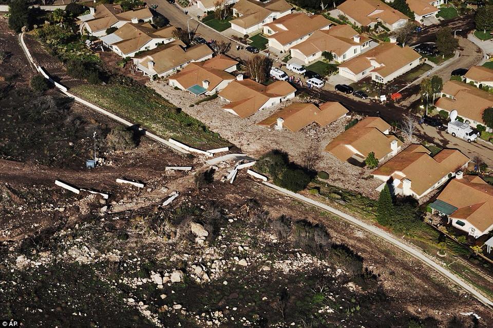 Devastation caused by mudslides in California. (Miami Pioneer / Facebook)
Update: On Wednesday evening, The Associated Press was reporting that the death count in the Southern California mudslides, debris slides and flooding had risen to 17.
After wildfires destroyed several areas in Southern California in December, rainstorms caused flooding and mudslides Tuesday that swept through the scorched Santa Ynez Mountains into the Los Angeles and Santa Barbara areas. The mud reached about 5 feet high in some places, destroying several homes and sweeping through roads.
As of Wednesday morning, the death toll had reached 15, with a majority of casualties in Montecito, the wealthiest community in Santa Barbara County. Authorities said they were still performing rescues after saving a 14-year-old girl in her home in Montecito. Footage of her rescue can be seen below:
EXCLUSIVE: 14-year-old girl pulled from rubble of mudslide in California: “I thought I was dead there for a minute.” https://t.co/3yXMAu8dOi@Miguelnbc has more on the mudslides tonight on @NBCNightlyNews. pic.twitter.com/pUAr15FiAP
— NBC Nightly News with Lester Holt (@NBCNightlyNews) January 9, 2018
Another victim whose car was caught in a mudslide was rescued by an air squad.
Victim who was swept away in their vehicle was located by the crew of AirSquad6. Victim was hoisted and flown to awaiting ground personnel. pic.twitter.com/RvX743x0yi
— VenturaCoAirUnit (@VCAirUnit) January 9, 2018
While thousands have evacuated across the area, about 300 people are reportedly trapped.
Debris from the mudslides has led the California Highway Patrol to close roughly 30 miles of U.S. Highway 101, a swath that is expected to stay closed for up to two days.
The interactive map below shows which areas are affected by the mudslides; it will be updated throughout the day.
USA Today provided a useful graphic on Twitter explaining how mudslides form:
Flooding and mudslides triggered by heavy rains swept away homes, overwhelmed roads and prompted widespread rescues in areas of Southern California left vulnerable by last month’s devastating wildfires. https://t.co/g52PPwmiuN pic.twitter.com/ZF7KsOKPvM
— USA TODAY (@USATODAY) January 9, 2018
California Sen. Kamala Harris took to social media to express her sympathy Tuesday night.
Horrible news for communities that have already suffered so much. It’s heartbreaking. Thank you to the firefighters and first responders who are working tirelessly in the face of these disasters.https://t.co/bTN4CNxPvi
— Kamala Harris (@SenKamalaHarris) January 9, 2018
Below are some of the photos of the devastation and rescue efforts posted on Facebook:
Your support matters…Independent journalism is under threat and overshadowed by heavily funded mainstream media.
You can help level the playing field. Become a member.
Your tax-deductible contribution keeps us digging beneath the headlines to give you thought-provoking, investigative reporting and analysis that unearths what's really happening- without compromise.
Give today to support our courageous, independent journalists.
 Environment
Regulators just imposed unprecedented fees on water usage in the state’s agricultural heartland.
Environment
Regulators just imposed unprecedented fees on water usage in the state’s agricultural heartland.
 TD Column
Inglewood, California’s gutted system previews a bleak future for American education.
TD Column
Inglewood, California’s gutted system previews a bleak future for American education.
 TD Original
After a review of his actions, John Eastman got placed on "involuntary inactive status" in California.
TD Original
After a review of his actions, John Eastman got placed on "involuntary inactive status" in California.
 Business & Economy
Studies have repeatedly shown wage increases bring few job cuts and boost local economies.
Business & Economy
Studies have repeatedly shown wage increases bring few job cuts and boost local economies.
 Politics
The Black progressive from Oakland carved out space for others to follow, including the Squad.
Politics
The Black progressive from Oakland carved out space for others to follow, including the Squad.
 Race
California is closer than any other state to realizing reparations for Black people. Now, the state faces a make-or-break moment.
Race
California is closer than any other state to realizing reparations for Black people. Now, the state faces a make-or-break moment.
You need to be a supporter to comment.
There are currently no responses to this article.
Be the first to respond.