‘Perfect Storm’ Threatens East Coast
Gale-force winds, drenching rain and a possible snowstorm: That's what much of the East Coast will face next week if forecasts predicting the collision of a trio of weather events -- Hurricane Sandy from the south, arctic air from the north and an early winter storm from the west -- come true.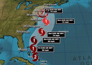
Gale-force winds, drenching rain and a possible snowstorm: That’s what much of the East Coast will face next week if forecasts predicting the collision of a trio of weather events–Hurricane Sandy from the south, arctic air from the north and an early winter storm from the west–come true.
“It’ll be a rough couple days from Hatteras up to Cape Cod,” said forecaster Jim Cisco of the National Oceanic and Atmospheric Administration. “We don’t have many modern precedents for what the models are suggesting.”
The storm is expected to hit Sunday and peak early Tuesday.
Your support matters…The Weather Channel:
It is likely to hit during a full moon when tides are near their highest, increasing coastal flooding potential, NOAA forecasts warn. And with some trees still leafy and the potential for snow, power outages could last to Election Day, some meteorologists fear. They say it has all the earmarks of a billion-dollar storm.
Some have compared it to the so-called Perfect Storm that struck off the coast of New England in 1991, but Cisco said that one didn’t hit as populated an area and is not comparable to what the East Coast may be facing. Nor is it like last year’s Halloween storm, which was merely an early snowstorm in the Northeast.
This has much more mess potential because it is a combination of different storm types that could produce a real whopper of weather problems, meteorologists say.
Independent journalism is under threat and overshadowed by heavily funded mainstream media.
You can help level the playing field. Become a member.
Your tax-deductible contribution keeps us digging beneath the headlines to give you thought-provoking, investigative reporting and analysis that unearths what's really happening- without compromise.
Give today to support our courageous, independent journalists.
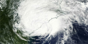
 Hurricane Dorian leaves devastation "unlike anything that we've ever seen before," an official says, with many still stranded in floodwaters.
 The Category 5 storm was heading toward the U.S. coast late on Monday.
 Panama City sets up a viable model amid lingering storm wreckage.
 News audiences were rarely informed about the contribution of human-caused climate disruption to the devastating storm, according to a recent study.
You need to be a supporter to comment.
There are currently no responses to this article.
Be the first to respond.