A River’s Wrath Comes to Steinbeck Country
Trillions of gallons of precipitation turned the Salinas River into a torrent.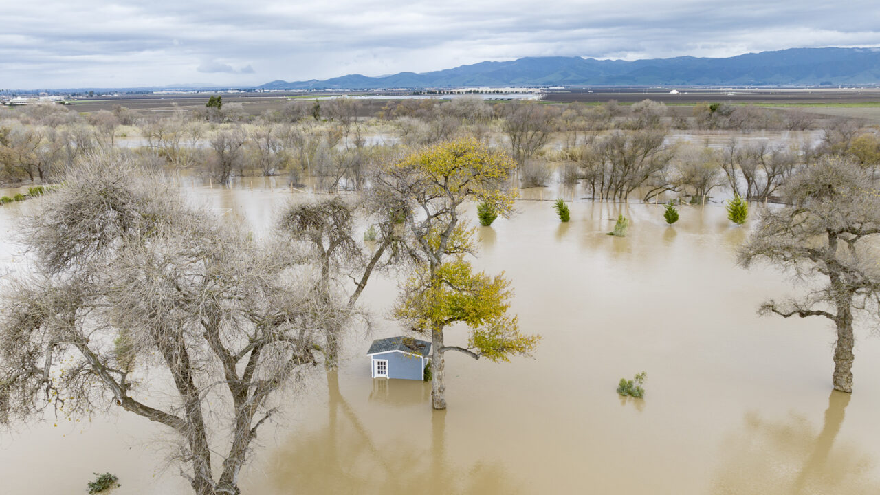 Floodwaters from the overflowing Salinas River surround a building during rain storms in Salinas, California, on Friday, Jan. 13, 2023. Photo: Josh Edelson / Getty.
On the surface, the Salinas River, which courses through the agricultural heart of California’s Central Coast, seems more like an ex-river. Even after major winter storms, it is rarely more than a creek. In Paso Robles, California, an old Spanish outpost that has since become a wine-growing mecca, the mostly dry riverbed cuts through an unprepossessing stretch of land surrounded by heaps of garbage and makeshift structures built by the city’s growing unhoused population.
And yet a closer look reveals signs of flood—scoured river stones, logs rolled smooth and clamshell fossils embedded in limestone from the uplands of the Temblor and Coast ranges. Only a river capable of occasional ferocity could have created this underlying landscape.
This winter, the Salinas reminded us of that fury. A series of atmospheric river storms transformed the Salinas River into a torrent. Fed by precipitation that, over the course of one month, dropped an estimated 30 trillion gallons across the state, the Salinas swelled to become, briefly, one of the largest rivers in the state. On the outskirts of Monterey, near the tiny farming town of Chualar, the river excavated a hole in a levee and poured floodwater into the surrounding fields. On San Marcos Creek, a typically dry tributary, a five-year-old boy was swept from a car and into the torrent. His body has not yet been found. So extreme was the flooding that water experts feared a repeat of the flood of 1995, when the Salinas overtopped its banks and created a moat around the city of Monterey, temporarily turning the peninsula into an island and isolating it from the rest of California.
The Salinas River is still an important waterway, central to California’s history and critical to the state’s $50 billion agricultural industry. And yet, few words have been written about the “upside-down river,” so called because it runs underground for long distances through a valley so thoroughly beaten into agricultural submission that it has come to be known as the nation’s “salad bowl.”
The river’s invisibility means that it’s overlooked and underexamined. Unlike the embattled mountain rivers surging from the High Sierra—the Tuolumne, the San Joaquin, the Stanislaus, the Kern—the Salinas has few chroniclers or defenders.
Driven to the floodplain by civic indifference and a misplaced belief that the usually dry river posed no threat, the Salinas’s river-bottom dwellers suffered more than anyone else.
The Salinas River does figure prominently in the works of John Steinbeck, who was born in the city of Salinas, near the river’s terminus. In East of Eden, shortly before his prophetic passage on California’s willful water-supply amnesia (“And it never failed that during the dry years the people forgot about the rich years, and during the wet years they lost all memory of the dry years. It was always that way.”) Steinbeck offers us a seldom-seen vision of the Salinas:
From both sides of the valley little streams slipped out of the hill canyons and fell into the bed of the Salinas River. In the winter of wet years the streams ran full-freshet, and they swelled the river until sometimes it raged and boiled, bank full, and then it was a destroyer. The river tore the edges of the farm lands and washed whole acres down; it toppled barns and houses into itself, to go floating and bobbing away. It trapped cows and pigs and sheep and drowned them in its muddy brown water and carried them to the sea.
Those words aptly describe the scene I encountered in January, some 70 years after the novel’s publication. Drought seemed a distant memory; the green hillsides contrasted with the Salinas’s swift, muddy current. Along River Road, I met a couple taking their morning walk on a muddy path along the swollen Salinas. In the nearly 30 years they’ve lived in town, the man told me, he has never seen the Salinas so large—though, he added, in decades past, the river did carry a larger and more consistent flow. “There used to be a slaughterhouse right here,” he said, gesturing to a row of riverside homes. “They would discharge blood straight into the river. The water was always red.”
As I headed out of town on Highway 101, the rain started up, battering the windshield. In the brief breaks between downpours, the land morphed into a foggy dreamscape. I stopped at a pullout overlooking the river and the massive San Ardo oilfield. A rainbow arched over the Gabilan Range in the distance. A few months earlier, these hills were sun-blistered and desolate. Now they glowed a vivid green, and the river ran with a roar, carrying dozens of massive logs in its current.
I hoped to reach the water’s edge by way of a potholed oilfield road. But a barricade and two private security trucks blocked the way. Inside one of the vehicles, a man lounged back in his seat, seemingly asleep.
It’s only because I’ve driven this stretch of Highway 101 dozens, perhaps hundreds, of times that I have begun to notice that there are no scenic pullouts to draw attention to the valley’s namesake river, no preserves or riverside parks. Usually, the only sign a river is there at all is a blue squiggle on a GPS map — an abstraction that masks the reality, which is that what remains of the river is eternally yoked to industry.
Indeed, in many parts of California, poverty follows geography—the lower in elevation you go, the poorer the people get, and the waterways are the lowest points of all. On the Salinas, the problem is particularly acute. In recent years, a growing homeless population has congregated not only along the Salinas’s banks but in the riverbed itself.
Driven to the floodplain by civic indifference and a misplaced belief that the usually dry river posed no threat, the Salinas’s river-bottom dwellers suffered more than anyone else. In Paso Robles, dozens of makeshift encampments sprang up along roadways, above the Salinas’ high-water mark. Dazed-looking people stood on streetcorners beside piles of rain-soaked belongings. At a ramp onto Highway 101, a man trudged up the muddy embankment, a water container on one shoulder and a bike laden with clothing and other items on the other.
Despite our best efforts to engineer it out of existence, the Salinas’s brief and violent reanimation is a reminder that it remains a very real waterway.
In King City, the setting of Steinbeck’s East of Eden, I drove through a subdivision called Rio Vista, where muddy waters were steadily engulfing a sprawling encampment built in the floodplain. I parked behind a Kentucky Fried Chicken and walked to the edge of an embankment for a better view of the place, with its ramshackle structures built of cast-off plywood, driftwood and bits of plastic. The inhabitants were nowhere to be seen, although an enormous pile of belongings heaped on the riverbanks suggested that whoever lived in the riverbed had gotten out in time.
Indeed, in many parts of California, poverty follows geography—the lower in elevation you go, the poorer the people get, and the waterways are the lowest points of all. On the Salinas, the problem is particularly acute. In recent years, a growing homeless population has congregated not only along the Salinas’s banks but in the riverbed itself.
Driven to the floodplain by civic indifference and a misplaced belief that the usually dry river posed no threat, the Salinas’s river-bottom dwellers suffered more than anyone else. In Paso Robles, dozens of makeshift encampments sprang up along roadways, above the Salinas’ high-water mark. Dazed-looking people stood on streetcorners beside piles of rain-soaked belongings. At a ramp onto Highway 101, a man trudged up the muddy embankment, a water container on one shoulder and a bike laden with clothing and other items on the other.
In King City, the setting of Steinbeck’s East of Eden, I drove through a subdivision called Rio Vista, where muddy waters were steadily engulfing a sprawling encampment built in the floodplain. I parked behind a Kentucky Fried Chicken and walked to the edge of an embankment for a better view of the place, with its ramshackle structures built of cast-off plywood, driftwood and bits of plastic. The inhabitants were nowhere to be seen, although an enormous pile of belongings heaped on the riverbanks suggested that whoever lived in the riverbed had gotten out in time.
As I write, the river is steadily subsiding. From its peak flow—over 15,000 cubic feet per second—at the town of Soledad, it had dropped to just under 1,800 cubic feet per second by Jan. 25. For now, the Salinas is still a decent-sized river. Soon, however, barring another major storm, the river will turn upside-down again and vanish into the sands.
Despite our best efforts to engineer it out of existence, the Salinas’s brief and violent reanimation is a reminder that it remains a very real waterway. The recent floods underscore the point that we are not in control. When the next major storm comes—next year, next decade or next century—the river will again become a destroyer. Farms, homes, jobs and lives depend upon our remembering that.
Your support matters…Independent journalism is under threat and overshadowed by heavily funded mainstream media.
You can help level the playing field. Become a member.
Your tax-deductible contribution keeps us digging beneath the headlines to give you thought-provoking, investigative reporting and analysis that unearths what's really happening- without compromise.
Give today to support our courageous, independent journalists.
 Health & Wellness
Meat and dairy groups have paid for advertisements that cast meat-based alternatives as unhealthy, unnatural and ultra processed.
Health & Wellness
Meat and dairy groups have paid for advertisements that cast meat-based alternatives as unhealthy, unnatural and ultra processed.
 Health & Wellness
Government-backed factory farming has become a dominant force in the last five decades.
Health & Wellness
Government-backed factory farming has become a dominant force in the last five decades.
 Environment
In addition to being the main cause of animal cruelty in the world, factory farming is a primary source of environmental degradation.
Environment
In addition to being the main cause of animal cruelty in the world, factory farming is a primary source of environmental degradation.
 Business & Economy
There is a massive movement, backed by billions of dollars, to keep animal meat on our tables and plant-based meat back in the fads of the pandemic.
Business & Economy
There is a massive movement, backed by billions of dollars, to keep animal meat on our tables and plant-based meat back in the fads of the pandemic.
 World
Small-scale farmers and Indigenous groups say they have again been shut out of the UN Food Systems Summit.
World
Small-scale farmers and Indigenous groups say they have again been shut out of the UN Food Systems Summit.
 Environment
A major piece of agricultural legislation will shape the future of the American food system.
Environment
A major piece of agricultural legislation will shape the future of the American food system.
You need to be a supporter to comment.
There are currently no responses to this article.
Be the first to respond.