Midwest Flooding Closes Stretches of Major River, Interstate
Flooding still a big concern in the lower Missouri River area after a massive storm affects parts of Nebraska, South Dakota, Iowa and Minnesota.OMAHA, Neb. — Flooding in the central U.S. on Friday forced some residents along waterways to evacuate, threatened to temporarily close a nuclear power plant and closed stretches of a major river and an interstate highway, foreshadowing a difficult spring flooding season.
The high water prompted by a massive late-winter storm, pushed some waterways to record levels in Nebraska, South Dakota, Iowa and Minnesota. The flooding was the worst in nearly a decade in places, though the situation was expected to improve quickly over the weekend, according to Mike Gillispie, National Weather Service hydrologist in Sioux Falls.
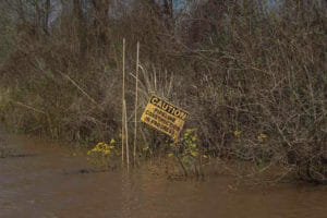
Flooding remained a big concern in the lower Missouri River region — which is a major source for the Mississippi River — with the weather service issuing warnings of high water along the river and its tributaries from southeastern South Dakota to St. Louis in Missouri.
Officials in eastern Nebraska said more than 2,600 people living along the Missouri, Platte and Elkhorn rivers there had been urged to evacuate, as waters breached levees in several rural spots.
“Things are moving and changing at a rapid pace,” Douglas County Commissioner Mary Ann Borgeson said Friday at a news conference. “We need you to follow instructions and evacuate when we say you need to evacuate.”
Dozens of people also had been rescued from flooding vehicles and buildings, Omaha Fire Chief Dan Olsen said at the news conference.
That included several first responders in two rescue boats that capsized on the Elkhorn River late Thursday night near Fremont. The boats capsized as they tried to reach people surrounded by floodwaters. Nebraska State Patrol helicopters were used to pull the crew members from the frigid water. Olsen said some were in the water “for an extended period” and were taken to a Fremont hospital for treatment. All are expected to fully recover.
Rising waters on the Missouri River also led Iowa officials on Friday to shut down much of Interstate 29 from the Missouri state line north about 85 miles (137 kilometers) to about Missouri Valley, Iowa. The closure was reminiscent of historic flooding along the river in 2011 that saw segments of the interstate in western Iowa washed away. Officials on Friday said the river is expected to crest well below what was seen in 2011.
The U.S. Coast Guard on Friday shut down all traffic on the Missouri River from about 50 miles (80.5 kilometers) south of Omaha, Nebraska, downstream to St. Joseph, Missouri, a stretch of about 70 miles (112.7 kilometers).
The Coast Guard and Corps also requested all river vessel operators create as little wake as possible between St. Joseph downstream to Kansas City to minimize levee damage.
The restrictions came as the river reached moderate flood stage at nearly 32 feet on Friday at Omaha, where it’s expected to crest at nearly 34 feet on Monday, according to the National Weather Service. The river is expected to crest at St. Joseph on Tuesday at just over 30 feet. Major flood stage at St. Joseph is 27 feet.
The U.S. Army Corps of Engineers, which manages the river, increased releases from Gavins Point Dam in southeastern South Dakota due to limited storage capacity behind the dam for the excess runoff. The releases could worsen flooding downstream, though the agency was helping with levee monitoring and other flood response measures, and it stopped releases from Fort Randall Dam upstream from Gavins Point.
The swollen Missouri threatened a nuclear power plant in southeastern Nebraska. The Nebraska Public Power District said it was likely the Cooper Nuclear Station about 59 miles (95.5 kilometers) south of Omaha would be shut down early Saturday.
Officials are confident that the flooding around the plant presents no danger to the public, power district spokesman Mark Becker said.
The storm also significantly increased spring flood worries in the Red River Valley in the Upper Midwest, where the neighboring cities of Fargo, North Dakota, and Moorhead, Minnesota, experienced a record flood 10 years ago.
The two cities have implemented several measures such as home buyouts and levees since then. They could be tested this year. The National Weather Service in an updated outlook Friday said “significant” snowmelt flooding is likely in the valley. The chance the river will reach major flood stage in Fargo increased from 50 percent last week to 90 percent.
The midweek storm crippled parts of Colorado and Wyoming with blizzard conditions . More than 25,000 homes and businesses were still without power Friday in Colorado, mostly in the Denver area. Xcel Energy said crews were being brought in from other states to help restore service. Most schools and government offices in the two states were reopening Friday.
The storm also spawned at least three tornadoes in Michigan and Indiana on Thursday, according to the National Weather Service. There are no immediate reports of any injuries, but homes and trees were damaged and power was knocked out to thousands. Flooding, hail and strong winds also were reported in parts of the two states. The weather service recorded a 60 mph (97 kph) wind gust at Indianapolis International Airport.
Your support matters…Independent journalism is under threat and overshadowed by heavily funded mainstream media.
You can help level the playing field. Become a member.
Your tax-deductible contribution keeps us digging beneath the headlines to give you thought-provoking, investigative reporting and analysis that unearths what's really happening- without compromise.
Give today to support our courageous, independent journalists.
 This marks the first time waivers have applied to federal procurement rules. Previously ones waived environmental impact reviews.
 In Louisiana, misdeeds by the oil and gas pipeline industries have fired up people dedicated to monitoring the situation—and they could use some help.
 A federal judge deems safety evaluations of the Dakota Access pipeline insufficient and orders the Army Corps of Engineers to reconsider its analysis.
You need to be a supporter to comment.
There are currently no responses to this article.
Be the first to respond.