May Days’ Heat Sets Up Record El Niño
High global temperatures last month made it one of the hottest Mays ever, and scientists believe it might have paved the way for a record-breaking El Niño weather phenomenon.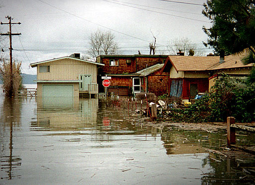
By Tim Radford, Climate News NetworkThis piece first appeared at Climate News Network.
LONDON — Last month was the third warmest May since NASA satellites began taking the temperature of the planet 35 years ago, and was also the warmest May that did not fall within an El Niño Pacific warming event — which could mean a record-breaking appearance this year by the fearsome “Child”.
Scientists in the US says the global average was 0.33°C warmer than the seasonal norms for the month. The warmest May ever was in 1998 during the “El Niño of the century”, when global average temperatures rose by 0.56°C, and the second warmest at 0.45°C was in 2010, another El Niño year.
So if indications are correct that an El Niño event is taking shape in the Pacific right now off the equatorial coast of South America, then it could become a record-setter — even if it isn’t a very spectacular event — just because it will get a warmer start, according to John Christy, professor of atmospheric science at the University of Alabama in Huntsville, US.
Temperature patterns
An El Niño (Spanish for The Child, because it was first observed by Peruvian fishermen around Christmas) is a shift in the temperature patterns of the Pacific, as a blister of equatorial ocean heat moves eastwards. It is a natural cyclic event that tends to reverse the prevailing Pacific weather patterns, often damagingly, and is not connected with climate change — although its effects could be made worse by climate change.
“The long-term baseline temperature is about three tenths of a degree warmer than it was when the big El Niño of 1997-1998 began, and that event set the one month record,” Christy said. “With the baseline so much warmer, this upcoming El Niño won’t have very far to go to break that 0.66°C record. That isn’t to say it will, but even an average-sized warming event will have a chance to get close to that level.”
Meanwhile, according to new research in Nature Climate Change, people in the northern hemisphere can also expect warmer temperatures in autumn and winter – in spite of last winter’s spectacular ice storms in the US north-east that shut down cities from the Atlantic to the Midwest, and where — to the joy of headline writers — the town of Hell in Michigan froze over.
Extremes of cold
The report’s author, James Screen, Natural Environment Research Council research fellow at the University of Exeter, UK, says that even though there will be extremes of cold, these will be less frequent and less severe. The Arctic is warming, and a study of autumn and winter temperature variations shows that variability in the temperate zone overall has in fact decreased.
“Autumn and winter days are becoming warmer on average, and less variable from day to day,” Dr Screen said. “Both factors reduce the chance of extremely cold days.
“Cold days tend to occur when the wind is blowing from the north, bringing Arctic air south into the mid-latitudes. Because the Arctic air is warming so rapidly, these cold days are now less cold than they were in the past.”
Your support matters…Independent journalism is under threat and overshadowed by heavily funded mainstream media.
You can help level the playing field. Become a member.
Your tax-deductible contribution keeps us digging beneath the headlines to give you thought-provoking, investigative reporting and analysis that unearths what's really happening- without compromise.
Give today to support our courageous, independent journalists.
 Economic Justice
The White House's 'Solar for All' program is designed to reduce greenhouse emissions and energy inequity.
Economic Justice
The White House's 'Solar for All' program is designed to reduce greenhouse emissions and energy inequity.
 Editorial Cartoons
 Activism
Indigenous peoples around the world are harassed and killed at alarming rates. Will the world act?
Activism
Indigenous peoples around the world are harassed and killed at alarming rates. Will the world act?
 Editorial Cartoons
 Environment
Regulators just imposed unprecedented fees on water usage in the state’s agricultural heartland.
Environment
Regulators just imposed unprecedented fees on water usage in the state’s agricultural heartland.
 Environment
Despite record heat waves and biblical floods, Middle Eastern leaders continue to do as little as possible to combat the reality of climate change.
Environment
Despite record heat waves and biblical floods, Middle Eastern leaders continue to do as little as possible to combat the reality of climate change.
You need to be a supporter to comment.
There are currently no responses to this article.
Be the first to respond.