Louisiana Battles ‘Unprecedented’ Flooding
As the planet warms, another "extreme" weather event strikes.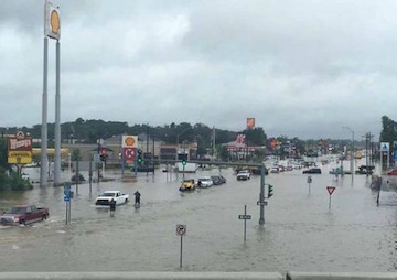 Floodwaters in Denham Springs, La., east of the state capital, Baton Rouge. (Louisiana Department of Transportation and Development)
By Andrea Germanos / Common Dreams
Floodwaters in Denham Springs, La., east of the state capital, Baton Rouge. (Louisiana Department of Transportation and Development)
Louisiana continued to battle “unprecedented” flooding on Sunday, as experts warn that the historic rainfall that sparked the rising waters is the kind of extreme weather event to expect on a warming planet.
Over 7,000 people have been rescued, at least three people have died, and a state of emergency has been declared.
“This is unprecedented,” Louisiana Gov. John Bel Edwards said Saturday. “Please don’t rely on your experiences in the past.”
He further warned on Sunday, “It is ongoing. It is not over.”
Edwards and “and his family were even forced to leave the Governor’s Mansion when chest-high water filled the basement and electricity was shut off,” the Associated Press reports. “That’s never happened before,” Edwards said.
As NBC News reported:
The heavy rain began on Friday, with between 6 and 10 inches of rain falling on parts of southeast Louisiana. Several more inches fell Saturday, according to the National Weather Service.
In a 24-hour period, Baton Rouge had as much as 11 inches, according to The Associated Press.
Meteorologists Jeff Masters and and Bob Henson write Sunday that “widespread rainfall amounts in excess of twenty inches since Friday have brought all ten river gauges on the Amite, Tickfaw, and Comite Rivers to record flood crests, flooded thousands of homes, and caused over 1,000 water rescues.” They add: “Some of the 24-hour rains that fell on Friday in Louisiana (ending at 11AM CDT/16UTC) had a recurrence interval at over 500 years, according to Metstat.”
They further explain:
The amount of moisture in the atmosphere over the Gulf Coast region over the past week has been nothing short of phenomenal. Over multiple days, soundings of the atmosphere collected by weather balloon from locations such as New Orleans have measured record or near-record amounts of precipitable water (the amount of moisture in the atmosphere over a given point), often in the 2.5” to 2.75” range; sounding data extends back to 1948 in most cases. Sunday morning’s precipitable water of 2.61” in Lake Charles, LA, was among the top-ten values on record for that station.
“From the air homes in southwest Louisiana looked more like little islands surrounded by flooded fields,” AP reported, though “From the ground it was just as catastrophic.”
Meteorologist Eric Holthaus wrote at Pacific Standard that the event is “at least the eighth 500-year rainfall event across America in little more than a year, including similarly extreme downpours in Oklahoma last May, central Texas (twice: last May and last October), South Carolina last October, northern Louisiana this March, West Virginia in June, and Maryland last month.”
He goes on to call it “the latest in a string of exceptionally rare rainstorms that are stretching the definition of ‘extreme’ weather. It’s exactly the sort of rainstorm that’s occurring more frequently as the planet warms.”
Author and climate activist Bill McKibben, meanwhile, suggested on Twitter that though it’s Louisianans currently facing the flood waters, the extreme event should serve as a message to all of us:
Your support matters…Gov of soaked Louisiana, talking to all of us on a heating world: “This is unprecedented. Please don’t rely on your experiences in the past”
— Bill McKibben (@billmckibben) August 14, 2016
Independent journalism is under threat and overshadowed by heavily funded mainstream media.
You can help level the playing field. Become a member.
Your tax-deductible contribution keeps us digging beneath the headlines to give you thought-provoking, investigative reporting and analysis that unearths what's really happening- without compromise.
Give today to support our courageous, independent journalists.




You need to be a supporter to comment.
There are currently no responses to this article.
Be the first to respond.