Hurricane Season: The Readiness Is All
Despite the lessons of Katrina, the U.S. is still incredibly vulnerable this hurricane season and looking toward a future -- and still lacking in vision -- that could spell serious trouble for previously pummeled targets like New Orleans, as well as some unexpected areas of the country.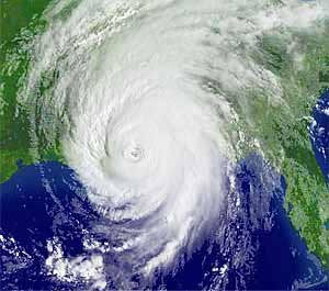
We’re just two weeks into the official Atlantic hurricane season, and already it’s looking like it could be a rough one. The first named storm, Andrea, formed off the coast of Florida in May, unusually early in the year. The second storm, Barry, spun up unexpectedly on June 1 in the Gulf of Mexico. Not since 1908 have two separate storms formed so early in the Atlantic. Neither Andrea nor Barry reached hurricane strength, but together they may hint at an atmosphere-ocean system that’s ripe for further storm development.
Indeed, every major pre-season hurricane forecast for the past several months has called for a busy year. The well-known Colorado State University forecasting team, comprised of Ph.D. student Phil Klotzbach and famed hurricane scientist William Gray, recently predicted 17 total named storms, nine of them hurricanes and five of them intense hurricanes (Categories 3 to 5), along with a heightened risk of an intense U.S. hurricane landfall. These forecasts have been wrong in the past, and especially last year, when an unexpected El Niño event in the Pacific Ocean helped suppress Atlantic hurricanes. But there are reasons for thinking the seasonal forecasters are not off base this time around. El Niño has gone away; its opposite, La Niña — which favors busy Atlantic hurricane years — may be setting in. Meanwhile, we’re in an undisputed active period for Atlantic storms, associated with warm tropical ocean temperatures, that began in 1995 and shows no sign of abating. If we don’t get hit hard this year, we will soon enough; there’s little doubt about this in the hurricane research community.
And it gets potentially worse. The current consensus of scientific experts, epitomized by reports from the World Meteorological Organization and the United Nations’ Intergovernmental Panel on Climate Change, is that global warming is going to alter hurricanes. Scientists don’t know precisely how, but it probably won’t be in a way that makes them more friendly. The storms are generally expected to be more intense on average (though not necessarily more numerous) and to rain more. Ongoing sea level rise will further ensure that they penetrate farther inland when making landfall. Wind, rain, storm surges: that pretty much covers all the chief sources of hurricane damage. Indeed, we may have seen a hint of how global warming could change hurricanes last week when Cyclone Gonu became the first recorded Category 5 storm in the Arabian Sea, and went on to cause considerable death and destruction in Oman and Iran. Of late the hurricane-global warming debate has shifted to focus on the Atlantic in particular, where some scientists believe that climate change is also driving an increase in the total number of storms (though other experts question that conclusion).
In the U.S., all of this ought to worry us not a little, because our vulnerability to hurricanes is staggering. Hurricane Katrina revealed one — but only one — area of massive exposure. If a powerful hurricane hits the tough-to-evacuate Florida Keys, or tears over the state’s inland Lake Okeechobee, driving its waters toward the dike that protects people from the lake (as happened in 1928), we could see even more deaths than we saw in New Orleans two years ago.
Loss of life is the worst thing we must fear from these storms, but loss of property and infrastructure can also be considerable. If struck by an intense hurricane, major cities like Miami, Houston and Tampa Bay could see Katrina-scale tragedies, with damages totaling in the tens of billions of dollars — or even, in the case of Miami, over $100 billion. (The estimated damage total if the devastating 1926 Miami hurricane were to occur today is a staggering $164 billion.) Glancing up the East Coast, meanwhile, we also have to worry about Savannah, Charleston, much of North Carolina and especially the Outer Banks … all the way up to New York City, which has been hit directly by a hurricane in the past and will be again one day. During the 1938 storm dubbed the “Long Island Express,” downtown Providence, R.I., was under water.
As these details suggest, many U.S. cities have been pummeled by strong hurricanes in the past, but we have made ourselves considerably more vulnerable than we were back in the 1920s and ’30s. As the National Hurricane Center notes, as of 1990, 85 percent of U.S. coastal residents had never experienced a major hurricane landfall. Since that time, the number of these inexperienced residents has only increased, as what some hurricane scientists dub our “lemming-like march to the sea” has proceeded apace. Today, 53 percent of the U.S. population lives within 50 miles of a coastline.
In essence, then, as hurricane season approaches this year, and looking forward to future years as well, we must survey a troubling canvas. It’s a picture dotted with short-term and long-term risks; but also with a heavy smattering of chance layered everywhere and a frame of scientific uncertainty around the edges. (The figure standing in the foreground of the painting — is that George W. Bush dressed up as a shepherd? — symbolizes government incompetence, and the lack of foresight and long-term thinking.)
To respond to this troubling image, let’s begin with some indisputable premises. We all recognize that Katrina devastated New Orleans, that our government responded inadequately and that recovery is going slowly at best. Furthermore, it ought to be obvious that the woeful failure to listen to expert warnings about the vulnerability of New Orleans, and translate those warnings into some type of massive project to protect the city from an entirely predictable disaster, signals a clear lack of leadership and vision. It ought not be acceptable in America to sustain such catastrophic damage to a major city. We’re just lucky that Katrina wasn’t worse: The center of the storm missed New Orleans by a good margin.
And New Orleans is just one exposed city among many. Efforts to refortify it after Katrina, wanting though they may be, certainly exceed what is being done in other places. New Orleans has gotten all the attention, after all. Not only was it devastated, it still ranks No. 1 on the International Hurricane Research Center’s top ten list of hurricane-vulnerable places. But there are many other ways that hurricanes can hurt us, including scenarios that are almost never talked about and may even be unknown to residents of vulnerable areas. For example, a rare hurricane affected what is now modern-day San Diego in 1858, when few people lived there; a repeat of this occurrence today could be a real shocker. In 1939, a tropical storm also struck Long Beach, Calif., killing 45 people. If storms forming off the coast of Mexico can on rare occasions travel as far north as San Diego and Long Beach, might they also someday reach Los Angeles?
In the face of all this, consider an immodest proposal: Let’s move now with a national project to protect our most vulnerable areas against hurricane devastation, not just for the present, but with an eye toward our globally warmed future. We can prioritize by starting with the most exposed places and then moving down the list.
Despite all the criticism of recovery efforts, in some respects New Orleans provides a model for how to proceed. In a recent New York Times article, reporter John Schwartz detailed how the city is attempting to use the best available science to study its future vulnerability. The U.S. Army Corps of Engineers is using complicated computer models to reassess risk by studying a wide range of possible scenarios for storms that could hit New Orleans in the future. Variations on storm size, strength, speed, rainfall and track are all being examined, as are global warming scenarios that could modify some of these variables.
We should apply precisely this mode of analysis to our other areas of vulnerability. To some extent that’s being done already — witness this report exploring what a Category 4 storm could do to Tampa Bay, or this report exploring a bad scenario for Houston — but it ought to be a coordinated and comprehensive national project. Furthermore, once we’ve analyzed and ranked all the worst-case scenarios, tough decisions will have to be made about how to apportion resources to prevent them from happening. In the case of New Orleans, for instance, any long-term defense plan will likely involve massive engineering projects to rebuild levees and create storm barriers over water. In other places, strategies may well be different. Sure, it will all cost a fortune. But nowadays most Americans would probably view such an investment as a much better one than, say, the war in Iraq.
The underlying theme is that now, more than ever before, we’re fully equipped and able to rationally analyze risks and worst-case scenarios. Which means it will be harder and harder to make excuses if we nevertheless allow them to be realized.
Chris Mooney is Washington correspondent for Seed magazine and author of the forthcoming book “Storm World: Hurricanes, Politics, and the Battle Over Global Warming” (www.stormworldbook.com).
Your support matters…Independent journalism is under threat and overshadowed by heavily funded mainstream media.
You can help level the playing field. Become a member.
Your tax-deductible contribution keeps us digging beneath the headlines to give you thought-provoking, investigative reporting and analysis that unearths what's really happening- without compromise.
Give today to support our courageous, independent journalists.
 Economic Justice
The White House's 'Solar for All' program is designed to reduce greenhouse emissions and energy inequity.
Economic Justice
The White House's 'Solar for All' program is designed to reduce greenhouse emissions and energy inequity.
 Editorial Cartoons
 Activism
Indigenous peoples around the world are harassed and killed at alarming rates. Will the world act?
Activism
Indigenous peoples around the world are harassed and killed at alarming rates. Will the world act?
 Editorial Cartoons
 Environment
Regulators just imposed unprecedented fees on water usage in the state’s agricultural heartland.
Environment
Regulators just imposed unprecedented fees on water usage in the state’s agricultural heartland.
 Environment
Despite record heat waves and biblical floods, Middle Eastern leaders continue to do as little as possible to combat the reality of climate change.
Environment
Despite record heat waves and biblical floods, Middle Eastern leaders continue to do as little as possible to combat the reality of climate change.
You need to be a supporter to comment.
There are currently no responses to this article.
Be the first to respond.