Floods Damage Colorado Oil and Gas Drilling Sites; Leaks Feared
Environmentalists and state inspectors are trying to track thousands of oil and gas wells, pipelines and fracking storage tanks to determine the scope of impairment from the region's massive floods. "They're just overwhelmed," one expert says.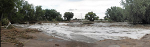
In addition to the loss of at least eight lives and uncounted millions of dollars in property damage, northern Colorado could be facing an environmental catastrophe after floodwaters tore through an area rife with oil and gas wells and pipelines, and storage tanks filled with fracking liquid.
And state officials are ill equipped to even assess the scope of the damage, and potential problem. According to the Boulder Daily Camera, state inspectors won’t begin to inspect the impaired sites until conditions improve. Meanwhile, local environmentalists were trying to track the damage on their own .
Lafayette-based anti-fracking activist Cliff Willmeng said he spent two days “zig-zagging” across Weld and Boulder counties documenting flooded drilling sites, mostly along the drainageway of the St. Vrain River. He observed “hundreds” of wells that were inundated. He also saw many condensate tanks that hold waste material from fracking at odd angles or even overturned.
“It’s clear that the density of the oil and gas activity there did not respect where the water would go,” Willmeng said. “What we immediately need to know is what is leaking and we need a full detailed report of what that is. This is washing across agricultural land and into the waterways. Now we have to discuss what type of exposure the human population is going to have to suffer through.”
There were reports of at least one pipeline broken by the raging floodwaters, which were the result of recent forest fires, a severe drought and the sudden downpour of more than 17 inches of rain in some areas. The oil and gas industry said wells in the flooded regions were shut down to avoid leaks, but no one knows how many were still operating, or what other sorts of leaks occurred from damaged storage tanks and ruptured pipelines.
The Colorado Oil and Gas Conservation Commission has only 18 inspectors to cover the entire state, according to the Colorado Independent.
It was clear that the state commission simply lacks the personnel to oversee an industry working over 50,000 drill sites.
“Initially, the agency is using GIS mapping to identify oil and gas locations within flooded areas of the South Platte River and its tributaries, and will work to determine which locations have been affected,” COGCC reported in a press statement. The Commission will form teams to focus on locations north and south of the South Platte River to perform field inspections.
“They’re just overwhelmed – more than overwhelmed,” said Dr. Kenneth Carlson, a professor of Civil and Environmental Engineering at Colorado State University.
—Posted by Scott Martelle
.
Your support matters…Independent journalism is under threat and overshadowed by heavily funded mainstream media.
You can help level the playing field. Become a member.
Your tax-deductible contribution keeps us digging beneath the headlines to give you thought-provoking, investigative reporting and analysis that unearths what's really happening- without compromise.
Give today to support our courageous, independent journalists.
 Opinion
In the last decade or so, 24 states have legalized cannabis for adult use. There’s a reason none have turned back.
Opinion
In the last decade or so, 24 states have legalized cannabis for adult use. There’s a reason none have turned back.
 TD Original
Colorado Rep. Ken Buck is trying to keep the farther-right Lauren Boebert from returning to Congress. Will it work?
TD Original
Colorado Rep. Ken Buck is trying to keep the farther-right Lauren Boebert from returning to Congress. Will it work?
 Politics
Under the banner of voting reform, a tycoon’s plan could give the rich even more power to buy elections.
Politics
Under the banner of voting reform, a tycoon’s plan could give the rich even more power to buy elections.
 Editorial Cartoons
 Editorial Cartoons
 TD Original
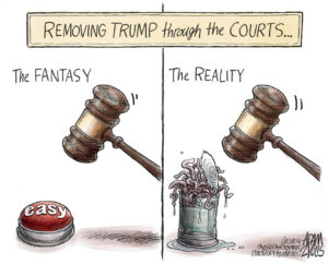
Just as it rescued George W. Bush in 2000, today’s Republican-dominated court will find a way to save Donald Trump from the insurrectionist label.
TD Original
Just as it rescued George W. Bush in 2000, today’s Republican-dominated court will find a way to save Donald Trump from the insurrectionist label.
You need to be a supporter to comment.
There are currently no responses to this article.
Be the first to respond.